Updated FAQ
1. How will this project affect traffic, parking and loading in the area?
1. A painted, buffered bike lane (1.5m bike lane/ 0.6m hatched buffer area) on the left (east) side of the street from just south of Cogswell Street to Terminal Road will be installed. This will be a part of a future connected bicycle network in the municipality as per the proposed Active Transportation Priorities Plan (External link).
2. There will be no parking allowed in the bicycle lane, but short stops to permit passenger pick up/ drop off and loading/ unloading will be allowed outside of peak traffic hours (7-9am & 4-6pm).
3. No accessible parking spaces will be significantly affected.
4. A new stop sign on Hollis at Terminal Road will be introduced.
5. Most parking meters on the right (west) side of the street will remain and some may be added. North of Salter Street, parking at meters will be restricted from 7-9am & 4-6pm to allow for an additional vehicle travel lane during peak travel times.
6. From Morris Street to Terminal Road, parking, stopping and loading will be virtually unchanged on both sides of the street.
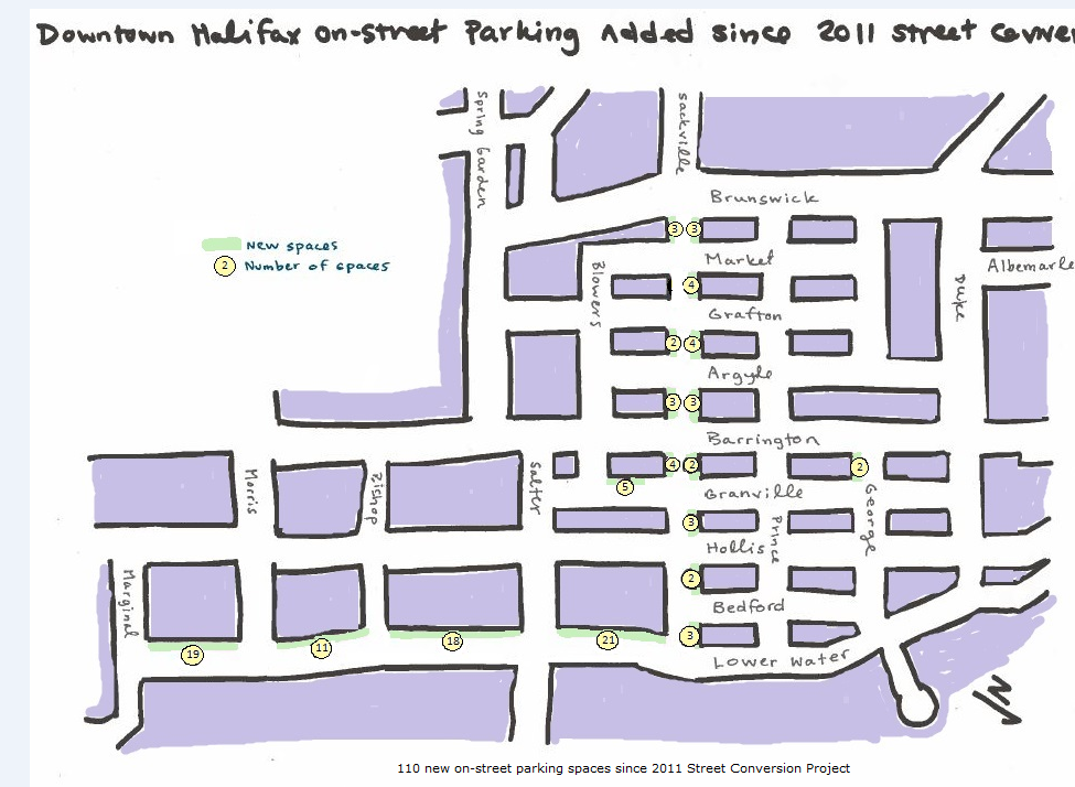
7. From Cogswell to Terminal Road, daytime parking spaces will be reduced from 80 spaces (today) to 60 spaces. Evening/ weekend parking spaces will be reduced from 156 today to 60 spaces. While this is unfortunate, nearby evening/ weekend parking is always available in various parking garages and surface parking lots. Also, the downtown street conversion project generated about 110 new parking spaces downtown to date, offsetting any loss of parking on Hollis Street.
2. Why is stopping off-peak going to be allowed in the bicycle lane?
1. Nova Scotia law restricts parking in bicycle lanes but permits short stops to drop off/ pick up passengers or load/ unload goods, unless signed otherwise. Based on observations that cycle traffic dropped after 9am, and feedback from abutting property owners that being able to load on both sides of the street was ideal, Halifax staff have tried to balance the various demands on the street by restricting stopping when cycle & motor vehicle traffic is heaviest, and allowing stopping when cycle and motor traffic is lighter.
2. If the limited stopping controls proposed for the bicycle lane (no stopping 7-9am/ 4-6pm) result in excessive blockage of the bicycle lane and/ or cycle demand increases beyond these times the stopping controls may be revisited in the future at which time alternative locations for loading would also be contemplated.
3. What direction should cyclists go in the bicycle lane?
Even though it is on the left side, the bicycle lane will still be for southbound travel only. All of the signs, signals, and pavement markings will be oriented for southbound travel.
4. Why is there no barrier between the bicycle lane and the vehicle travel lane?
A protected bike lane is an exclusive bicycle facility that is physically separated from motor traffic and also distinct from the sidewalk. Physical separation will not be provided at this time because vehicles will be allowed to pull over to the left curb and stop briefly in the bicycle lane (i.e. to drop off passengers or goods) in the off-peak hours (9am – 4pm and 6pm -7am). Cycle traffic counts have suggested that bicycle volumes drop significantly outside of peak times. The lane will be monitored and there may be consideration for a protected facility in the future.
5. Why can't there be parking in the bike lane on evenings and weekends?
The Nova Scotia Motor Vehicle Act restricts parking in bicycle lanes at all times (but allows brief stopping, unless signed otherwise as per the above). There is plenty of evening/ weekend parking nearby (in surface lots and parking structures, as well as on the street) so this was not considered to be a significant issue.
6. Why isn't the bicycle lane between the parking lane and the curb between Morris and Terminal Road?
This is the block in which the bike lane will be ending, so people who are cycling will need to transition back to the right side of the road if they are going straight, and to the right side of left turning vehicles if they are turning left. Riding between the curb and the parking lane would make these transitions much more challenging. Also, door zone conflicts between cyclists and vehicle doors are much reduced on the passenger side of motor vehicles.
7. Why is there a new stop sign at Terminal Road?
Because the existing configuration (stop control for Terminal Road and northbound Hollis only, but no stop control for southbound Hollis) no longer meets the Transportation Association of Canada guidelines for stop control at a T-intersection. The new stop sign means that all vehicles will be slowing down to stop, making it easier for people riding bicycles to merge and transition away from the left side bicycle lane before this point.
8. How will the contraflow bicycle lane on Upper Water Street work, and how does it help the network?
This short contra flow lane will provide improved connectivity between the North End/ Macdonald Bridge via the Barrington Greenway and Upper Water Street to the new bicycle lanes on Hollis Street. Southbound cyclists can’t use this route now because it ends at the Waterfront Marriott Hotel, where Upper Water becomes one way, northbound only. This project will include curb adjustments to allow people on bicycles to continue southbound and have access to the left side of Hollis Street after crossing the Cogswell Street ramps. Staff will be considering other options to enhance the connection from the Barrington Greenway along Upper Water as part of an interim treatment pending the redevelopment of the Cogswell Interchange.
9. Are any other enhancements to the streets being carried out in conjunction with the bicycle lane?
There will be curb ramps and pedestrian ‘bump-outs’ installed at the new stop sign at Terminal Road to facilitate pedestrian crossing of Hollis Street at this location.
The crosswalk over Hollis at the bottom of South Street will be replaced by a new crosswalk at Terminal Road (just 25m north of existing) at the new 3-way stop.
Pedestrian curb ramps will be improved at University/ Morris.
Surface improvements will be carried out where needed to improve the riding surface on the left side of the street and one catch basin cover with grills parallel to the direction of travel (not “bike friendly”) will be replaced.
Intersections on the corridor will be repaved improving the travel surface for all road users.
The traffic signals on Hollis have already been adjusted to provide a continuous “green wave” for vehicles traveling 30km/h. This means that a vehicle starting at a fresh green light at Duke Street will get a green light at the remaining traffic signals on Hollis Street if they can average 30km/h. While this may require a little effort, this speed is completely achievable on a bicycle.
10. What about Construction?
Construction of the Maple condominium at the southeast corner of Hollis and Sackville Streets is planned to continue until spring 2017. While there is construction hoarding in place over the left side of the street:
· 8 parking spaces are temporarily unavailable and the road is reduced to one travel lane immediately north and south of Sackville;
· People on foot should cross to the sidewalk on the other side of the street.
· People travelling southbound on bicycles should stay to the left side of the street through the construction zone.
11. What are the next steps?
The plan is being finalized now and implementation is targeted for summer 2015.
12. Why is the bicycle lane now on the left side of the street?
13. How are people on bicycles supposed to make a right turn from the left side of the street?
Just like making a left turn from a right side bicycle lane: shoulder check, signal, and then move toward the right curb before making your turn.