Share Halifax Mobility Response: Streets and Spaces on FacebookShare Halifax Mobility Response: Streets and Spaces on TwitterShare Halifax Mobility Response: Streets and Spaces on LinkedinEmail Halifax Mobility Response: Streets and Spaces link
Consultation has concluded
The Halifax Mobility Response Plan was initiated in May 2020 in response to changing mobility needs due to COVID-19. The goal of the Mobility Response was to repurpose the way we used our streets and sidewalks toprovide Space to Move, Space to Load, Space to Queue, and Space to Support Business.
The actions taken so far for the Mobility Response Plan include:
Expanding sidewalks on Spring Garden Road
Adjusting traffic signal timings at major intersections to reduce wait times for pedestrians
Creating temporary loading spaces for businesses
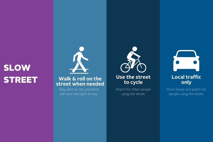
Limiting residential streets to local traffic to create slow streets to allow for physical distancing while walking, rolling and cycling
Creating space to support business by closing Argyle Street to all vehicle traffic between Prince and Blowers streets and Bedford Row before Prince Street, leaving lots of space for people to move and dine outdoors.
Between May and August, Halifax Regional Municipality collected hundreds of ideas for the Mobility Response Plan on Shape Your City using a crowdsourcing map. Thank you to everyone who provided ideas and suggestions. This feedback helped to shape some of the actions taken this summer and will continue to inform longer-term planning processes. To learn more about what we heard from this engagement.
It is expected, the Slow Streets measures, will be in place until September 30, 2020. This survey will help us to evaluate the actions taken so far under the Mobility Response Plan and help to provide direction for future actions and for other municipal initiatives like the Street Improvement Pilot Project program. This survey should take approximately 15 minutes to complete.
The Halifax Mobility Response Plan was initiated in May 2020 in response to changing mobility needs due to COVID-19. The goal of the Mobility Response was to repurpose the way we used our streets and sidewalks toprovide Space to Move, Space to Load, Space to Queue, and Space to Support Business.
The actions taken so far for the Mobility Response Plan include:
Expanding sidewalks on Spring Garden Road
Adjusting traffic signal timings at major intersections to reduce wait times for pedestrians
Creating temporary loading spaces for businesses
Limiting residential streets to local traffic to create slow streets to allow for physical distancing while walking, rolling and cycling
Creating space to support business by closing Argyle Street to all vehicle traffic between Prince and Blowers streets and Bedford Row before Prince Street, leaving lots of space for people to move and dine outdoors.
It is expected, the Slow Streets measures, will be in place until September 30, 2020. This survey will help us to evaluate the actions taken so far under the Mobility Response Plan and help to provide direction for future actions and for other municipal initiatives like the Street Improvement Pilot Project program. This survey should take approximately 15 minutes to complete.
Consultation has concluded
Share Mobility Response Plan - Space to Move & Support Business on FacebookShare Mobility Response Plan - Space to Move & Support Business on TwitterShare Mobility Response Plan - Space to Move & Support Business on LinkedinEmail Mobility Response Plan - Space to Move & Support Business link
The following streets will be designated as ‘slow streets’. They will be open to local traffic only, to reduce vehicle volumes and to create a space for residents to walk, roll and cycle while adhering to physical distancing guidelines.
Only those motorists who live, are visiting, or are accessing a business on these streets are considered local traffic.
Halifax: • Leaman, Drummond, and Isleville streets between Leeds and Almon streets • Connolly Street between Windsor Street and Chebucto Road • Elm Street between Chebucto and Quinpool roads • Beech Street between Quinpool and Jubilee roads • Peter Lowe Avenue between William Hunt and George Dauphinee avenues • Liverpool Street between Connaught Avenue and Windsor Street • Oak and Allan streets between Connaught Avenue and Windsor Street • Welsford Street between Windsor and Robie streets • Vernon Street between Pepperell and Watt streets • LeMarchant Street between Watt Street and University Avenue • Norwood Street between Connaught Avenue and Preston Street • Shirley Street between Preston and Robie streets
Dartmouth: • Chappell Street between Pinehill Drive and Wyse Road • Slayter Street between Albro Lake Road and School Street • Dahlia Street between Victoria Road and Crichton Avenue
Additional areas are being considered and will be communicated once confirmed.