Peninsula South Complete Streets
Phase 2 What We Heard Report
The Phase 2 What We Heard Report and Supplementary Report summarizing input from the second round of public engagement are now available for download.
August 2022 Update
Phase Two of public engagement has come to a close. Over the month of July, the project team hosted two virtual discussion sessions, two pop-up events at Dalplex and the VG hospital, and an online survey spanning three weeks. Thank you to everyone who attended our engagement events and/or responded to the survey. Your input will inform the next phases of the project.
While the comment period has closed, you can still view the interactive map with concept options and potential impacts using the link below:
INTERACTIVE CONCEPT MAPS (viewing only)
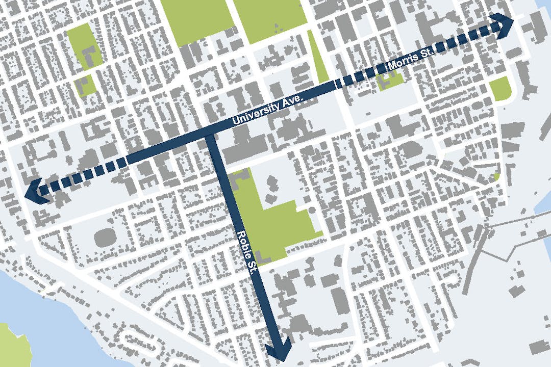
Overview of the Project
Improvements are being considered for several streets including University Avenue, Morris Street and Robie Street (south of University Avenue).
This project will apply a "complete streets" approach to improving mobility for people travelling through the south end of the Halifax peninsula, with a focus on improving comfort, safety and convenience for people walking and cycling while also considering transit, accessibility, placemaking, urban forestry, vehicle traffic, loading, parking and other factors.
The resulting functional plan will recommend improvements to pedestrian infrastructure and new all-ages-and-abilities (AAA) cycling connections along several streets as identified in the Integrated Mobility Plan and Active Transportation Priorities Plan.
The objective for the new AAA cycling routes is to:
- Connect the Halifax Urban Greenway to Lower Water Street, as well as Dalhousie University's three campuses and the hospitals along the way.
- Connect University Avenue to the Saint Mary’s University campus.
The project will also establish a common design vocabulary, or “District Identity,” for University Avenue that reflects the unique character of the area and will shape any changes made to the street.
We want to hear from you as we begin to develop the plan. Thank you to everyone who attended and participated in our two public workshops. We will also be hosting several pop-up sessions where residents will have the opportunity to contribute ideas and shape the future of the Peninsula South Complete Streets project. Please consider joining us!
What do we mean by “Complete Streets”?
Complete Streets is one of the Foundational Policies of the Integrated Mobility Plan (IMP). The objective of the policy is to “meet the needs of all ages, abilities and travel modes in the design and maintenance of streets.” This is achieved through a holistic, flexible and context-sensitive approach to designing new streets or changes to existing streets.
The Complete Streets approach implements multiple design features to accommodate various combinations of transportation modes, including walking, cycling, using transit and driving. The context and intended role of a street are critical factors in establishing a Complete Street design.
To learn more about the municipality’s Complete Streets approach, check out Section 2.3 of the Integrated Mobility Plan.
Phase 1 What We Heard Report
A What We Heard Report summarizing input from the first round of public engagement, which wrapped up in November 2019, is now available for download. The project team is currently evaluating the cycling route options for connections to the west and east of University Avenue. The preferred cycling routes, draft District Identity for University Avenue, and concepts for walking and cycling improvements will be shared for feedback during round two of public engagement in 2022.
Four Short Videos Explaining the Project and Concepts


Document Library
-
 Phase 2 What We Heard Report (2.87 MB) (pdf)
-
Phase 2 What We Heard Supplementary Report (234 KB) (pdf)
-
Peninsula South Complete Streets Concept Drawings (4.68 MB) (pdf)
-
Peninsula South Complete Streets Concept Evaluation Summary (125 KB) (pdf)
-
Peninsula South Complete Streets Potential Parking Changes (657 KB) (pdf)
-
 Phase 1 What We Heard Report (2.13 MB) (pdf)
-
Making Connections Booklet (10.6 MB) (pdf)
-
Site Feature Examples for Peninsula South Complete Streets (5.32 MB) (pdf)


Who's Listening
-

Phone 902-490-8474 Email nenerm@halifax.ca